Leeds (Quarry Hill Primitive Methodist)
Leeds • Quarry Hill, Leeds
0
Burial records
0
Inscriptions / photos
0
YAS burials
0
YAS inscriptions
No burials or inscriptions are currently available for this cemetery.
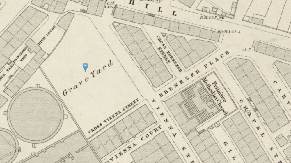
Location
- Also known as
- Ebeneser Chapel
- Location
- Quarry Hill, Leeds
- Postcode
- —
- Latitude / longitude
- 53.798850, -1.530180
Dates & affiliation
- Established year
- —
- Year commenced
- —
- Year concluded
- —
- Denomination
- —
- Status
- Unknown
Resources
- Map
- —
- Website
- —
- Contact
- —
Availability
No burial records currently on site
No inscriptions currently on site
This summary shows material currently available on Yorkshire Burials.
Record Summary
- Burial records on Yorkshire Burials
- 0
- Inscriptions / photos
- 0
- Transcribed registers
- 0
- Other sources & resources
- 2
- YAS burials
- 0
- YAS inscriptions
- 0
- Cemetery map
- No
- Repositories noted
- National Library of Scotland
Overview
Additional sources and supporting material have been identified in the Other Sources & Resources tab. Records or related material may be held by National Library of Scotland.
Nearby Cemeteries
Cemeteries within a selected radius of Leeds (Quarry Hill Primitive Methodist).
| Cemetery | Location | Distance |
|---|---|---|
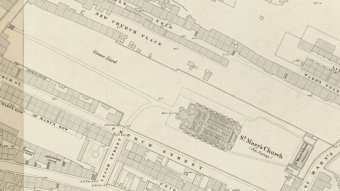
| Leeds, Mabgate (St. Mary's Church) | — | 0.12 miles |
| Leeds (St. James) (York Street) | York Street, Leeds | 0.33 miles |
| Leeds Parish Church (St. Peter) | 2-6 Kirkgate, Leeds | 0.34 miles |
| Leeds (Ebenezer Methodist New Connexion Chapel) | Ebenezer Street, Leeds | 0.36 miles |
| Leeds (St. John the Evangelist) | 23 New Briggate, Leeds LS2 8JD | 0.50 miles |
| Leeds (St. Saviours) | Ellerby Lane, Leeds | 0.51 miles |
| Leeds (Brunswick Wesleyan Methodist) | — | 0.51 miles |
| Leeds (Holy Trinity) | — | 0.57 miles |
| Leeds (Albion Independant Chapel) | Albion Street, Leeds | 0.65 miles |
| Leeds (Mill Hill Chapel - Unitarian) | City Square, Leeds LS1 5EB | 0.69 miles |
| Leeds Infirmary Grave Yard | Infirmary Street, Leeds | 0.77 miles |
| Burmantofts Cemetery (Beckett Street Cemetery) | Beckett Street, Leeds | 0.80 miles |
| Leeds (Camp Lane Court Friends Burial Ground) | Camp Lane | 0.81 miles |
| Leeds (Oxford Place Wesleyan Methodist) | Oxford Pl, Leeds LS1 3AU | 0.85 miles |
| Leeds (St. Paul - Park Square) | — | 0.88 miles |
| Leeds (St. George) | — | 0.96 miles |
| Leeds (Queen Street Congregational Chapel) | — | 1.00 miles |
| Hunslet (Wesleyan Methodist Chapel) | Whitfield Street, Hunslet, Leeds | 1.24 miles |
| Leeds General Cemetery (Woodhouse) | Woodhouse, Leeds | 1.27 miles |
| Woodhouse (St. Mark's Church) | Saint Mark's Church, St Mark's Rd, Leeds LS2 9AF | 1.30 miles |
| Hunslet Moor Road Burial Ground | — | 1.35 miles |
| Harehills Cemetery | Kimberley Rd, Leeds LS9 6LZ | 1.42 miles |
| Holbeck Balm Lane (Wesleyan Methodist Burial Ground) | — | 1.44 miles |
| Holbeck (St. Matthew) Old Church Yard | St Matthew's St, Holbeck, Leeds LS11 9NR | 1.51 miles |
| Holbeck Cemetery | Fairfax Road, Leeds | 1.88 miles |
| New Wortley | Grasmere Road, Leeds | 2.00 miles |
| Chapel Allerton (St. Matthew) | Church Ln, Chapel Allerton, Leeds | 2.04 miles |
| Hunslet (St. Mary) | Church St, Hunslet, Leeds LS10 2QY | 2.06 miles |
| Hunslet Cemetery | Middleton Road, Leeds | 2.06 miles |
| Hunslet Ext. 1 Cemetery | — | 2.12 miles |
| Hunslet Ext. 2 Cemetery | — | 2.20 miles |
| Beeston Cemetery | Beeston Road, Leeds | 2.23 miles |
| Beeston (St Mary's Church) | — | 2.32 miles |
| Headingley (St. Michael & All Angels) | St Michael's Rd, Headingley, Leeds LS6 3AW | 2.33 miles |
| Leeds Catholic Cemetery (Killingbeck) | Cemetery Cottage, York Rd, Seacroft, Leeds | 2.34 miles |
| Armley (St. Bartholomew) | Wesley Rd, Armley, Leeds | 2.35 miles |
| Upper and Lower Wortley | Oldfield Lane, Leeds | 2.44 miles |
| Wortley (St. John the Evangelist) | St John's Church, Dixon Ln Rd, Leeds LS12 4RU | 2.57 miles |
| Meanwood (Holy Trinity) | Church Ln, Meanwood, Leeds LS6 4NP | 2.70 miles |
| Roundhay (St. John the Evangelist) | St Johns House, Wetherby Rd, Roundhay, Leeds LS8 2LE | 2.76 miles |
| Cottingley Hall Cemetery | Elland Road, Leeds | 2.86 miles |
| Headingley (St. Chads) | Far, Otley Rd, Headingley, Leeds LS16 5JT | 3.06 miles |
| Kirkstall (St. Stephen) | Park Mount, Kirkstall, Leeds LS5 3HB | 3.09 miles |
| Whitkirk (Municipal) | Selby Road, Leeds | 3.18 miles |
| Seacroft (St. James Church) | The Grn, Seacroft, Leeds LS14 6JL | 3.19 miles |
| Whitkirk (St. Mary) | Selby Rd, Whitkirk, Leeds LS15 0AA | 3.29 miles |
| Leeds, Middleton (St Mary the Virgin Church) | Town St, Middleton, Leeds LS10 3TJ | 3.29 miles |
| Armley Cemetery | Greenhill Road, Leeds | 3.44 miles |
| Gildersome (United Hebrew Congregation Cemetery) | 253 Gelderd Rd, Leeds LS12 6DJ | 3.47 miles |
| Moor Allerton (St. John's Church) | Harrogate Rd, Leeds LS17 7BY | 3.47 miles |
| Manston (St James the Great) | Church Ln, Cross Gates, Leeds LS15 8JB | 3.51 miles |
| Churwell (Daffil Chapel Cemetery) | Crossland Road junction with Elland Road, Churwell, Leeds | 3.68 miles |
| Rothwell Cemetery | Haigh Road, Rothwell, Leeds | 3.86 miles |
| Rothwell (Holy Trinity Church) | Church St, Rothwell, Leeds LS26 0QL | 3.92 miles |
| New Farnley (St. Michael and All Angels) | Lawns Lane, Farnley Leeds, LS12 5EZ West Yorshire | 3.97 miles |
| Bramley (St. Peter) | Hough Ln, Bramley, Leed | 4.09 miles |
| Bramley (Zion Baptist) | — | 4.25 miles |
| Morley (St Peter's Church) | St Peter's Morley, Rooms Ln, Leeds | 4.27 miles |
| Lawnswood Cemetery & Crematorium | Otley Rd, Adel, Leeds | 4.29 miles |
| Shadwell (St. Paul) | St. Paul's Parish Church, Main St, Shadwell, Leeds LS17 8JF | 4.38 miles |
| New Farnley Cemetery | Tong Road, Leeds | 4.39 miles |
| Bramley (St Margarets Church) | The Rectory, Newlay Ln, Bramley, Leeds LS13 2AJ | 4.42 miles |
| Morley (Banks Hill Chapel) | Chapel Hill, Bank Street, Morley | 4.44 miles |
| Adel (Quaker Burial Ground) | New Adel Lane, Adel, Leeds | 4.53 miles |
| Morley (Rehoboth Independent Chapel) | Dawson Hill, Morley, Leeds | 4.59 miles |
| Morley (St Mary in the Wood United Reform Church) | Commercial St, Morley, Leeds | 4.60 miles |
| Adel (St. John the Baptist) | Church Ln, Adel, Leeds | 4.62 miles |
| Whinmoor Grange Cemetery | Thorner Lane, Leeds | 4.63 miles |
| Oulton cum Woodlesford (St. John the Evangelist) | 28 Leeds Rd, Oulton, Leeds | 4.66 miles |
| Lofthouse Cemetery | Cemetery Lane, Lofthouse, Wakefield | 4.74 miles |
| Morley (Central Methodist) | — | 4.77 miles |
| Morley (Zion Independent ) | 10 Haydn Cl, Morley, Leeds | 4.78 miles |
| Horsforth (St. James Woodside) | Low Ln, Horsforth, Leeds | 4.84 miles |
| Horsforth (Cragg Hill Baptist) | Baptist Church, 18 Cragg Hill, Horsforth, Leeds LS18 4NU | 4.94 miles |